- Reaction score
- 3,435
- Points
- 1,120
Well,
This evening, I was mucking about with a couple of things and ended up on the path of looking at some WWI Trench maps, through the McMaster University Archive:
http://library.mcmaster.ca/maps/ww1/ndx5to40.htm
Looking at maps, then discovered aerial photos:
http://lt1.mcmaster.ca/ww1/wrz4mp.php?grid=51b
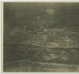
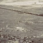
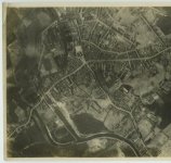
In particular, this one:
http://digitalarchive.mcmaster.ca/islandora/object/macrepo%3A4749/-/collection&view
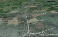
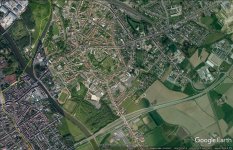
I was interested to see if I could find where the photo was taken, and what's still there today...here's my result from Google Earth:
This evening, I was mucking about with a couple of things and ended up on the path of looking at some WWI Trench maps, through the McMaster University Archive:
http://library.mcmaster.ca/maps/ww1/ndx5to40.htm
Looking at maps, then discovered aerial photos:
http://lt1.mcmaster.ca/ww1/wrz4mp.php?grid=51b
In particular, this one:
http://digitalarchive.mcmaster.ca/islandora/object/macrepo%3A4749/-/collection&view
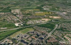
I was interested to see if I could find where the photo was taken, and what's still there today...here's my result from Google Earth: