• Thanks for stopping by. Logging in to a registered account will remove all generic ads. Please reach out with any questions or concerns.

Google-earth sightings....

George Wallace said:
How about these in Nevada for the dry land sailor or the largest CD's in the world:

39°57'24.84"N  117°25'26.75"W
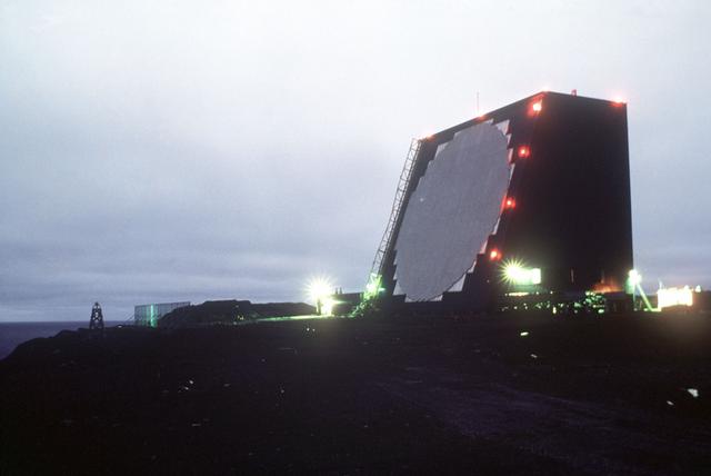
Remember flying over those in a Herc going from Pet to San Diego and wondered what they were at the time.

Check this one out  48°51'27.11"N  10°12'19.07"E
 
zipperhead_cop said:
I don't know navy so well, so can someone explain what the underwater rectangles are in this one? 

36 54'15.08" N 122 27'48.70" E

It could be BS but I have been told that China is buying up all the Grade A lumber and sinking it in harbours for some reason.....
 
NavyShooter said:
43°16'31.14"N  79°51'20.55"W

43°37'48.85"N  79°24'45.00"W


Seeing double??????

HMCS Haida was in Toronto, but it has been moved to Hamilton.  Its the same ship, with pictures taken at different times
 
Just goes to show you how dated some of those images are.  Try googling you house and neighbourhood and see if there is anything that should be there, but isn't.  When was that last building started, or when was that street/road built and is it in the imagery.

I like the bug.  Either it is a balloon that is being inflated for a fest or someone is tampering with the imagery for fun.
 
George Wallace said:
I like the bug.  Either it is a balloon that is being inflated for a fest or someone is tampering with the imagery for fun.
Perhaps the effects of toxic waste.  Quick, call out the army!!
 
36 54'15.08" N 122 27'48.70" E

AN/FPS-108 Cobra Dane

cobra-dane-DFST8404789_JPG.jpg
 
Interesting thing about google earth....have a look at China for example.  Vast areas of it are at low res....but look around at the areas that are hi-res....every one of them has something potentially "interesting"....I found one airbase in the middle of nowhere with over 75 fighter aircraft (Mig 21 type mostly) hanging around.

Jump from Hi-res to Hi-res in china and see what you crop up?

NS
 
The reason some places are higher res then others is based on how many times people search for it. The more popular the area is the higher res the images get. (why spend the time and resources getting high res images of someplace nobody is interested in seeing?)
 
NavyShooter said:
Interesting thing about google earth....have a look at China for example.  Vast areas of it are at low res....but look around at the areas that are hi-res....every one of them has something potentially "interesting"....I found one airbase in the middle of nowhere with over 75 fighter aircraft (Mig 21 type mostly) hanging around.

Jump from Hi-res to Hi-res in china and see what you crop up?

NS
Some areas of China "conveniently" have a cloud blotting out the area. ::) Perhaps they are military instillations that they do not want us seeing.
 
52°44'13.39"N  174° 5'26.60"E

There's the Cobra Dane radar....

NS
 
52°59'32.31"N  158°39'5.46"E

Apparently a secret Chinese training facility.

http://abcnews.go.com/Technology/story?id=2266192&page=1
 
55° 7'57.15"E    25° 7'13.48"N

http://www.concretemonthly.com/monthly/images/2005_08/dubai.jpg


Dubai has got to be one of the coolest looking citys from the air
 
zipperhead_cop said:
Anybody from Alberta know if this is for real?

50° 0' 38.20", -110° 6' 48.32"

Not sure never seen/Heard of that before...But anythings possible...
 
NavyShooter said:
52°44'13.39"N  174° 5'26.60"E

There's the Cobra Dane radar....

NS

Right you are, NS.  Although my tag in G-E's "My Places" is correct, I must have copied the oyster beds co-ords after I had already copied the Cobra Dane's co-ords.  :-\  Thanks for the pick-up. 


Cool look at an active volcano just past the Kamchatka Penninsula...especially when you tilt the view... 50°19'16.60"N  155°27'59.59"E 


G2G
 
Munxcub said:
The reason some places are higher res then others is based on how many times people search for it. The more popular the area is the higher res the images get. (why spend the time and resources getting high res images of someplace nobody is interested in seeing?)

Well that explains why the small towns in BC I want to look at are low res... :(
 
Come on now, Ymir, BC is a vacation hot spot. ;D  I would seriously love to see some more high res images of areas in that province in the Kootenays.  Nice scenery and it used to be popular with the army as a training area in the sixties, or so I am told.
 
I must be having a brain fart, but I can't seem to get co-ordinates from Goggle earth.
I can enter them, but, having found somthing interesting, can't send it on.

Any help?
 
Back
Top